What Is Archaeology
Archaeology is the scientific study of human history and prehistory through the excavation and analysis of artifacts, structures, and other physical remains left behind by past peoples. It bridges the gap between written history and the deep human past, giving voice to civilizations that left no texts.
How Archaeologists Reconstruct the Past
Archaeologists use excavation, field surveys, laboratory analysis, and increasingly, digital tools like LiDAR and ground-penetrating radar to uncover evidence of past human activity. Their work is methodical, slow, and deeply precise — every layer of soil tells a story.
What Does an Archaeologist Do
An archaeologist designs and carries out field research, records and catalogs finds, analyzes materials in the lab, and publishes findings that contribute to our collective understanding of human culture and behavior. Some focus on specific time periods, others on particular regions or material types.
Archaeology Definition in Practice
The archaeology definition goes beyond digging up old things. It is a discipline built on hypothesis testing — archaeologists form research questions, gather physical evidence, and interpret data to draw conclusions about how people lived, worked, and believed.
Archaeology vs Anthropology
Archaeology and anthropology are closely related but not the same discipline. Anthropology is the broad study of humans — their biology, language, culture, and social behavior — while archaeology specifically focuses on the material remains of past human life. In the United States, archaeology is often taught as a subfield of anthropology, while in much of Europe it is treated as a separate discipline.
The distinction matters because the two fields ask different questions. Anthropologists may study living communities directly; archaeologists can only work with what was left behind, which demands a different set of interpretive skills.
Types of Archaeology
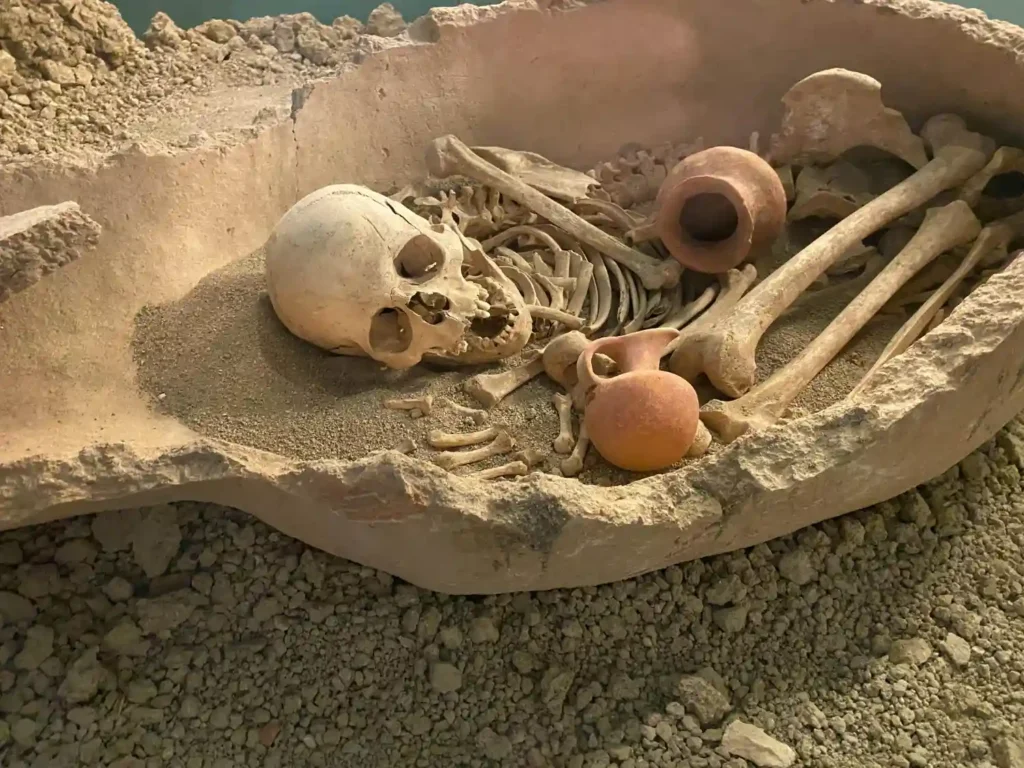
Different types of archaeology reflect the range of questions the discipline can answer. Prehistoric archaeology examines cultures before written records. Historical archaeology combines material evidence with documentary sources. Underwater archaeology investigates submerged sites. Forensic archaeology applies field methods to criminal investigations. Bioarchaeology focuses on human skeletal remains to understand health, diet, and mobility in past populations. Each specialization requires its own set of methods, but all share the same core commitment to evidence-based interpretation.
The diversity of archaeological subfields means that the discipline touches nearly every aspect of human experience, from ancient trade routes to religious practices to everyday household life.
Archaeological Discoveries
Archaeological discoveries have repeatedly reshaped our understanding of history. The unearthing of Göbekli Tepe in Turkey pushed back the origins of monumental architecture by thousands of years, challenging assumptions about what early hunter-gatherer societies could accomplish. The discovery of the Rosetta Stone unlocked Egyptian hieroglyphics and opened an entire civilization to modern scholarship.
These finds are not just academic milestones. They challenge assumptions, fill in missing chapters, and sometimes overturn what was considered settled historical fact.
History of Archaeology
The history of archaeology as a formal discipline begins in the 19th century, though antiquarian interest in ancient remains goes back much further. Early excavations were often treasure hunts with little regard for context. The development of stratigraphy — the study of soil layers — by figures like William Flinders Petrie brought scientific rigor to the field.
The 20th century saw archaeology expand into a fully professionalized science. New dating technologies like radiocarbon dating transformed how sites are analyzed. Today, digital documentation, satellite imaging, and isotopic analysis have made modern archaeology more powerful and precise than at any point in its history. With skilled writers handling projects, these services like https://essaypro.com/do-my-homework produce essays that demonstrate depth, organization, and clarity.